![]()
愛知県渥美半島戦争遺跡(歴史をめぐって…)
日本の近現代史を語るなかで、帝国主義、そして幾多の戦争は、切り離せないもので、愛知県の渥美半島に暮らしていた人々の暮らし にも、大きく影響を与えていた。
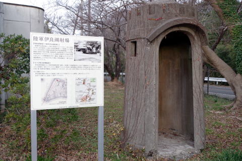
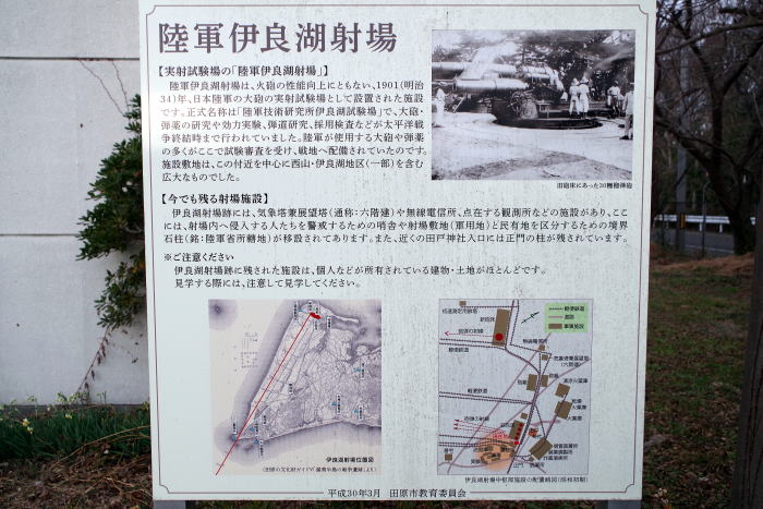
渥美半島の先端部の平坦な地形を生かして造られた、陸軍の試砲場(伊良湖試験射場)は、1906年(明治39年)伊良湖試験射場の用地拡大により、伊良湖村の全村民729名が集団で移転した。これは当時の国策であり、従わざるを得ないものであった。
一方で伊良湖試験射場に関する仕事に就職する機会が生まれ、人の移動や物流が活発になるなど良い効果もあり、昭和初期頃の国策による渥美線の延長計画は、伊良湖試験射場への物資輸送が目的だったとされている。鉄道が開通すれば地域にとっても便利になるはずでしたが、日中戦争以降の長く続く戦争で資材不足となったためか工事は中断された。
また、太平洋戦争終末期には米軍の上陸に備えて、陸軍第73師団を始めとする多くの兵士が駐留し、太平洋側の海岸沿いや山の中に陣地を築いた。
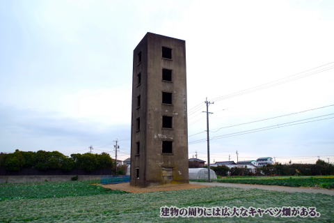
太平洋戦争終戦後、伊良湖試験射場は閉鎖され、広大な敷地には開拓団が入り、苦難の開墾作業を経て、現在は一面にキャベツ畑とトウモロコシなどが栽培されている。
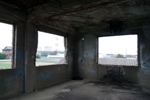
そして、当時を偲ばせる6階建ての気象観測塔の近くには、火力発電所や風力発電所も出来ている。

Irako launch site layout map
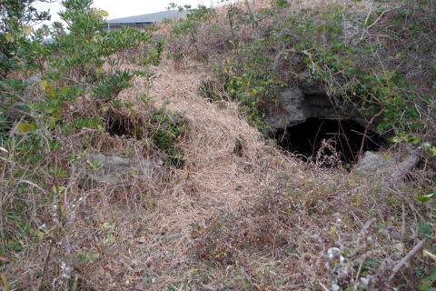
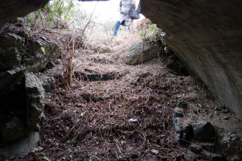
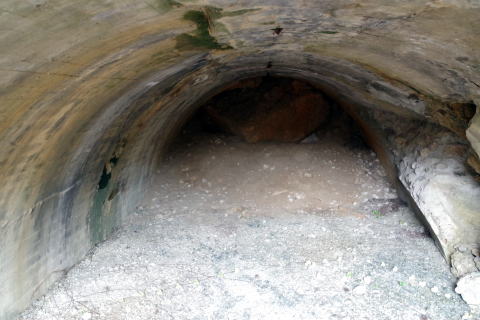
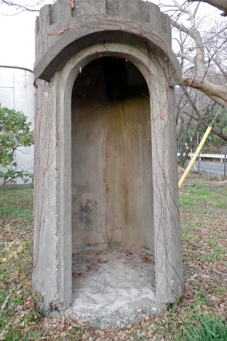
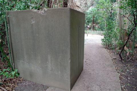
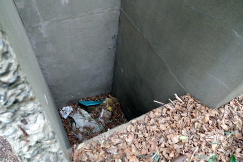
伊良湖ベトン:田原市伊良湖町宮下2822-2 (現伊良湖シーサイドゴルフ倶楽部内)
大砲の試射の着弾地点には、地元では「伊良湖ベトン」とよばれる設備があった。
資料によると、長さ約8メートル×幅3.2メートル×高さ1.7メートル
Irako Beton: 2822-2 Miyashita, Irako-cho, Tahara City (currently within Irako Seaside Golf Club)
At
the point of impact for the test firing of the cannon, there was a facility
locally known as ``Irako Beton''.
According
to the Atsumi Peninsula War Ruins (Tahara City Board of Education), ``It was
built to test how well concrete would break.'' In other words, it's a
bulletproof test facility. (Currently located near the golf course parking lot.)
According
to the document, it is approximately 8 meters long x 3.2 meters wide x 1.7
meters high.
The con
crete is 2 meters thick and is a valuable war relic, but there are no information
boards or anything like that.
伊良湖試験射場跡の周辺施設Facilities surrounding
the Irako Test and Launch Range ruins
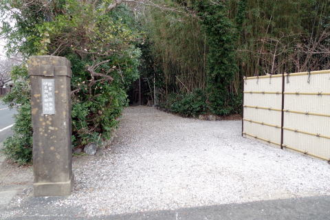
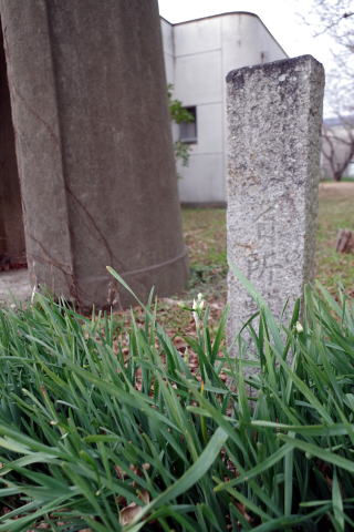
射場入口の門柱:田戸神社の道路向かいにある。
Gatepost
at the entrance to the firing range: Located across the road from Tado Shrine.

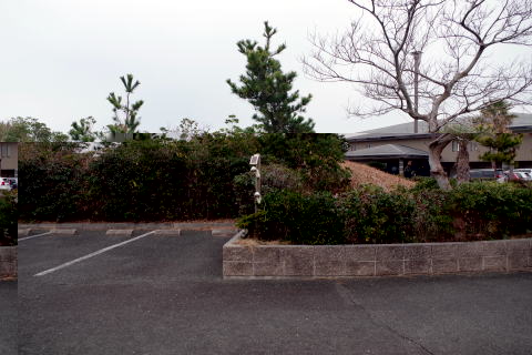
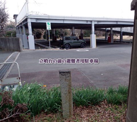
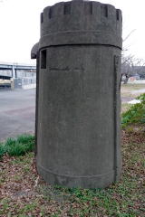
立哨台:小山中駐車場入口にある。(元:小山中児童公園、現:津波緊急雛難所)
Stand
guard house: Located at the entrance of the Konakayama parking lot. (Formerly:
Konakayama Children's Park, Currently:
Tsunami emergency nest shelter)

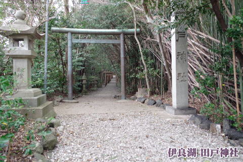
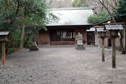
信管落下試験用施設跡:田戸神社内
Remains of the fuse drop test facility: inside Tado S


弾薬置き場:現在は民家、個人が所有。(所有者は親切に案内してくれました)
Ammunition
storage area: Currently owned by a private person.


実験棟事務所:個人が所有(小山中避難所奥)
Experimental
building: Konakayama evacuation center back.


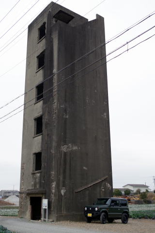
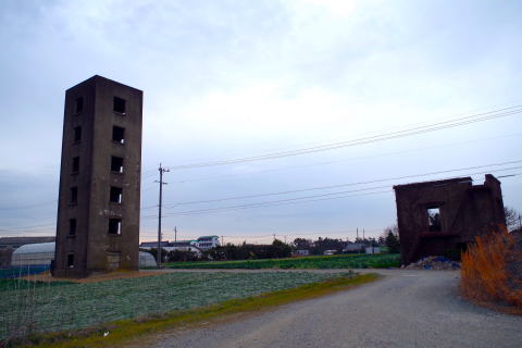
気象観測塔兼展望塔:伊良湖射場跡:(個人が所有:田原市中山町八幡上363-1)
Meteorological
tower and observation tower: Irako launch site ruins: 363-1Hachimanue Nakayama,
Tahara City


無線電信所跡:(個人が所有)
Wireless telegraph station ruins.


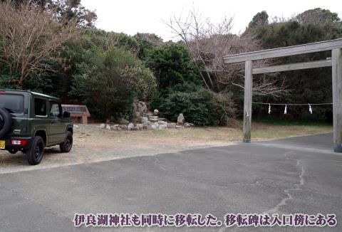
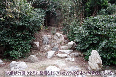
伊良湖集落移転百周年の記念碑(日出町)兵士像
Monument
commemorating the 100th anniversary of Irako village relocation (Hinode Town)
Soldier statue
「渥美町史」によると戦時中、大砲の試験をするための施設「伊良湖試験場」拡大のため1905年(明治38年)9月17日、軍用地として西山及び伊良湖地内を軍用地として買収しました。
伊良湖集落全戸(104戸)は翌1906年(明治39)年3月15日までに現在の所に移転をした。
その移転時、伊良湖神社もこの地に移った。記念碑の横には兵士像がある。
According
to the Atsumi Town History, during the war, Nishiyama and Irako land were
acquired as military land on September 17, 1905 in order to expand the Irako
Proving Ground, a facility for testing cannons.
All
the houses in Irako Village (104 houses) were moved to their current location
by March 15, 1906.
At
the same time, Irako Shrine was also moved to this location. There is a statue
of a soldier next to the monument.


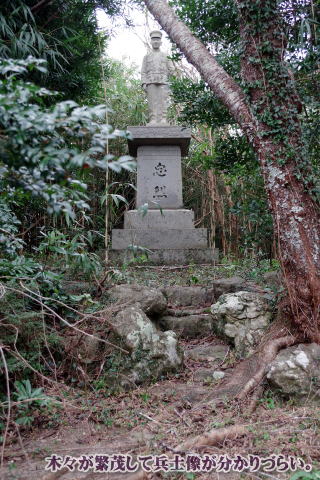


※兵士像:1915年に伊良湖に生まれ、1937年(昭和12年)の日中戦争に従軍して9月29日に戦死された小久保幸一郎氏の功績を顕彰するために伊良湖神社の参道入口に建てられた像。当時の人たちの戦死者への配慮を伺えられる。(出典:田原市教育委員会リーフレット)
*Soldier
statue: Located at the entrance to Irako Shrine to honor the achievements of
Koichiro Kokubo, who was born in Irako in 1915 and served in the Sino-Japanese
War in 1937, and was killed in action on September 29.
You
can see the consideration people had for those who died in war at the time.
(Source: Tahara City Board of Education leaflet)
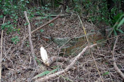
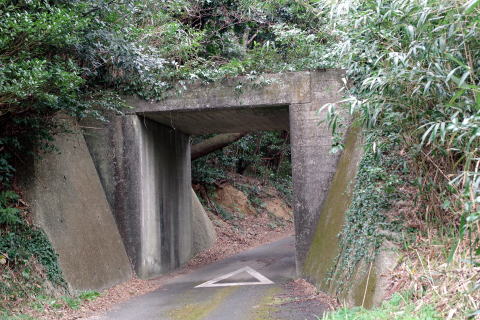
渥美線路盤に残る築堤とコンクリート橋(石神町):工事が途中でストップした幻の渥美線の痕跡
日中戦争以降の長く続く戦争で資材不足となったためか工事は中断された。
Embankment and
concrete bridge that remain on the Atsumi railway bed (Ishigami Town):
Traces of the
phantom Atsumi Line where construction stopped midway.
Construction
was halted, probably due to a shortage of materials due to the long war that
followed the war between Japan and China.

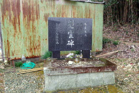
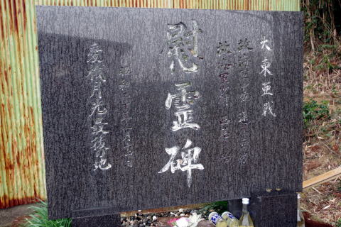
遠藤中佐と西尾少尉の慰霊碑(神戸町):
1945年名古屋空襲を終えて帰還するB29を遠藤中佐と西尾少尉が搭乗した「月光攻撃機」が追撃するなか被弾し、墜落した地点。最後まで民家を避ける努力をした。
Cenotaph for
Lieutenant Colonel Endo and Second Lieutenant Nishio (Kanbe Town):
This
is the spot where the Moonlight Attack Plane, piloted by Lieutenant Colonel
Endo and Second Lieutenant Nishio, was pursuing a B-29 returning from the
Nagoya air raid in 1945, when it was hit by a bullet and crashed.
I
made an effort to avoid private houses until the end.
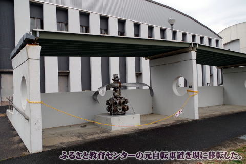
戦闘機のプロペラとエンジン
1944年か1945年ころに、豊橋市明海町にあった豊橋海軍航空隊基地から飛んできて墜落した海軍陸上攻撃機「銀河」のものと思われる。仁崎の海岸から1kmくらいの所に沈んでいたものを1973年に引き上げたもの。現在は「ふるさと教育センター」(旧野田中学校)の自転車置き場にある。
Fighter jet
propeller and engine
It
appears to be from the Navy land attack aircraft "Ginga" which flew
from the Toyohashi Naval Air Corps Base in Akemi-cho, Toyohashi City and
crashed around 1944 or 1945. It was pulled up in 1973 after sinking about 1km
from the coast of Nisaki. It is currently located in the bicycle storage area
of the Furusato Education Center (formerly Noda Junior High School).

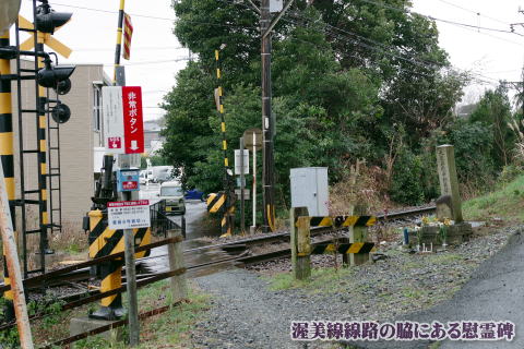
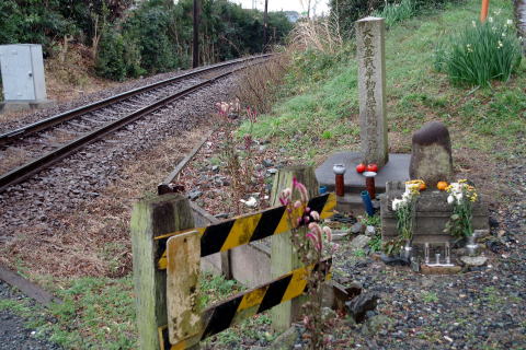
渥美線 機銃掃射被害跡地付近に建つ慰霊碑
1945年8月14日にアメリカ軍の戦闘機に渥美線三河田原駅を出発した電車が銃撃され一般人、学生など15人の即死者と16人の負傷者がでた悲惨な事件の慰霊碑。
Cenotaph built
near the site of the Atsumi Line machine gun attack damage.
This
cenotaph was built on August 14, 1945, when a train leaving Mikawa Tahara
Station on the Atsumi Line was shot at by an American fighter plane, killing 15
civilians and students instantly and 16 injured. It is a monument to a tragic
event.
It
was built next to the railroad tracks heading from present-day Kanbe Station to
Toyoshima Station
※余談:何故、伊良湖に観測所や渥美半島の山あいに砲台があるのか?
伊良湖水道を航行する敵艦隊を攻撃するはずの榴弾砲が、なぜこの様な山の奥にあるのか?
残念ですが、今回は、がけ崩れや学校敷地により観測所跡を見学できなかった。
また、田原市博物館の学芸員さんの親切丁寧な対応に感謝します。
<参考資料>Reference materials
Battle
ruins on the Atsumi Peninsula
渥美半島戦跡:田原市文化財5-1.eps (taharamuseum.gr.jp)
田原市戦跡:untitled
(taharamuseum.gr.jp)
https://www.taharamuseum.gr.jp/info/digital_archive/pdf/sensoiseki_leaflet.pdf
田原市広報誌:広報たはら平成24年8月1日号
1ページ 表紙 (PDF
259.1KB)
戦跡top