
岩手県宮古市 2022.10.30 Miyako City, Iwate Prefecture October 30, 2022
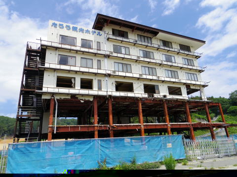
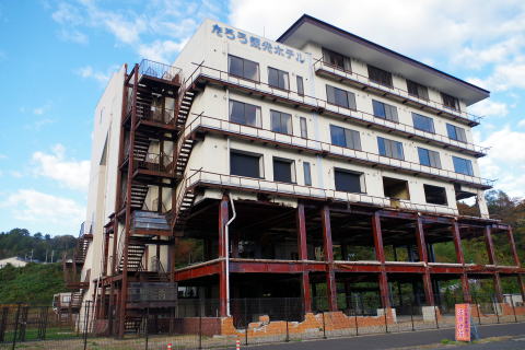
震災遺構 「たろう観光ホテル」岩手県宮古市田老地区 2014.6.24撮影
TARO tourist hotel " Miyako-shi, Iwate Taro
田老観光ホテルが建つ宮古市田老地区は、①1896年(明治津波)②1933年(昭和津波)そして今回2011年(東日本大震災)と、100年余で3度も津波が襲い壊滅的な被害を受けた地区。津波は高さ5mはある防潮堤を軽々と乗り越え、約800戸が流された。 ホテルはその堤防から約100mの所、津波の直撃で6階建ての3階まで壁がぶち抜かれ、赤さびた鉄骨や内装がむき出しになっている。
※2014年3月に初の震災遺構として登録され、現在は宮古市所有。
The Taro district of Miyako City, where the Taro Kanko Hotel is located, has been devastated by three tsunamis in over 100 years: (1) 1896 (Meiji Tsunami), (2) 1933 (Showa Tsunami), and this time in 2011 (Great East Japan Earthquake).
The tsunami easily climbed over a 5m-high seawall and washed away about 800 houses.
The hotel is about 100m from the embankment, and the walls of the 6-story building were pierced by the tsunami to the 3rd floor, exposing the red rusty steel frame and the interior.
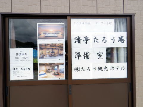
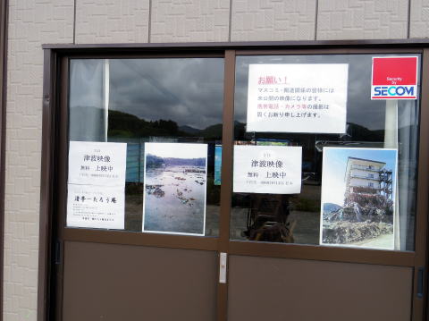
In addition, there is a prefabricated hut right next to the hotel, where Mr. Matsumoto, the president of the hotel, is showing a video taken from the 6th floor at the time, from just before the tsunami to the destruction of the city. (only seen here)
*In March 2014, it was registered as the first earthquake disaster ruins and is currently owned by Miyako City.
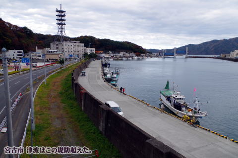
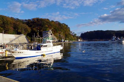
「田老漁港とたろう観光ホテル」"Taro Fishing Port & Taro Tourist Hotel"
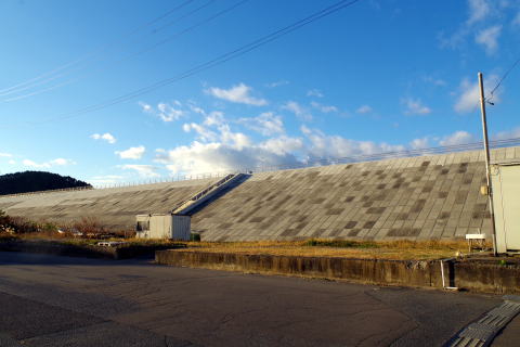
仮設住宅を後にして、漁港へと向かった。高さ5m以上あると思われる防潮堤の水門だけが残ったが、ひび割れが生々しい。漁港周辺の約800戸が、津波に流された。
漁船の流出は、850隻に及ぶ、防潮堤内にあった住宅は引き波ですべてが流され、あたり一面草が生え、何もない中に、たろう観光ホテルがぽつんと建っている。漁港では、壊れた堤防を再建するための工事が行われているが、防潮堤内の住宅地は手つかずのまま、その中で、たろう観光ホテルは、2014年3月に初の震災遺構として登録された。(2014年6月記)
We left the temporary housing and headed for the fishing port. Only the sluice gate of the seawall, which is thought to be more than 5m high, survived, but it has cracks. About 800 houses around the fishing port were swept away by the tsunami.
A total of 850 fishing boats were washed away, and all the houses inside the seawall were washed away by the undertow.At the fishing port, construction is underway to rebuild the broken embankment, but the residential area inside the embankment remains untouched. In March 2014, the Taro Kanko Hotel was registered as the first earthquake remains. (June 2014)
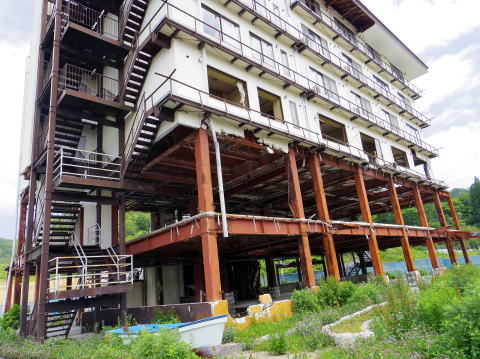
<震災遺構「たろう観光ホテル」~津波遺構保存整備事業~> 2022年10月30日撮影
たろう観光ホテルは、1986(昭和61)年に建設後、市民や観光客に愛される施設として、営業されてきた。2011(平成23)年3月11日の東日本大震災で、高さ17メートルを超えるとも言われる津波の被害を受けて、4階まで浸水、2階までは柱を残して流失しましたが、倒壊することなく現在の姿で留まった。
被害を受けた建物の取り壊しが進む中、宮古市では、甚大な被害の記憶を風化させることなく、後世に伝えるための「津波遺構」として保存することを決定した。
2014(平成26)年3月に宮古市が取得、2016(平成28)年3月までに、被災した「ありのままの姿を残すこと」を目的とした保存整備工事を終え、今後は、訪れる人々に津波の恐ろしさを伝え、訪れる人々の防災意識を高めることにより、震災による被害が繰り返されないよう、現在の姿のまま保存していく。
<Earthquake Remains “Taro Kanko Hotel” ~Tsunami Remains Preservation and Maintenance Project~>
Since its construction in 1986, Taro Kanko Hotel has operated as a facility loved by citizens and tourists. In the Great East Japan Earthquake on March 11, 2011, the tsunami, which is said to have exceeded 17 meters in height, flooded the building up to the 4th floor and washed away the 2nd floor, leaving pillars behind. However, it remained in its present form without collapsing.
As the demolition of damaged buildings progressed, Miyako City decided to preserve the memory of the enormous damage as a "tsunami remains" to pass down to future generations.
Acquired by Miyako City in March 2014. By March 2016, the preservation and maintenance work for the purpose of "preserving the original appearance" of the damaged area will be completed. By conveying the terror of tsunamis to people and raising awareness of disaster prevention among visitors, we will preserve the current state of the building so that the damage caused by the earthquake will not be repeated.

https://www.city.miyako.iwate.jp/kanko/tsunamiikoutaroukankouhotel.html
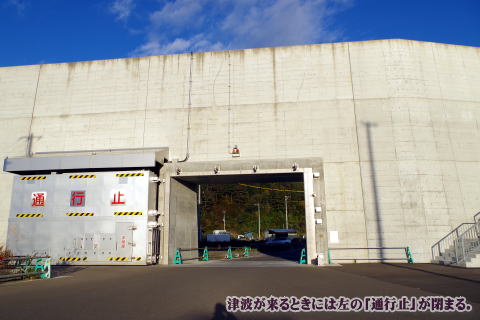
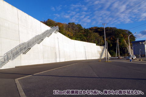
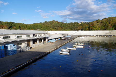
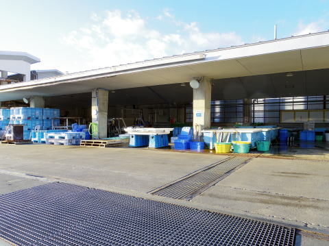
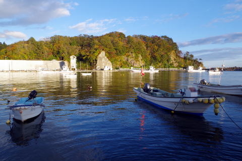
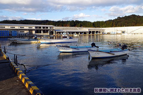
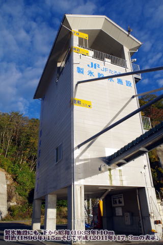
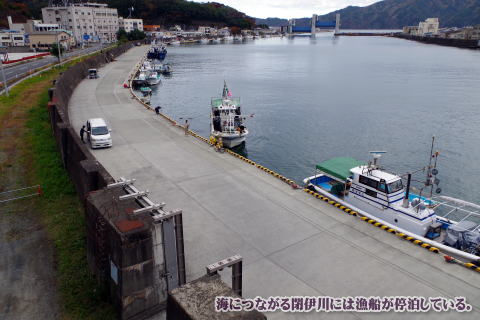
<防潮堤とたろう漁港>
高さ15mの防潮堤の向こうのたろう漁港がある。製氷施設の壁と裏手の岩山に、明治、昭和、平成の津波の高さが表示されている。2014年に来た時は、まだ防潮堤は無かったし津波の傷跡が痛々しかったが、今の漁港は穏やかに夕陽を浴びていた。
<Tide embankment and Taro fishing port>
On the other side of the 15m-high seawall is Taro Fishing Port. The height of the tsunami during the Meiji, Showa, and Heisei periods is displayed on the wall of the ice-making facility and on the rocky mountain behind it. When I came here in 2014, the seawall had not yet been built and there were scars from the tsunami, but now the fishing port was gently bathed in the setting sun.

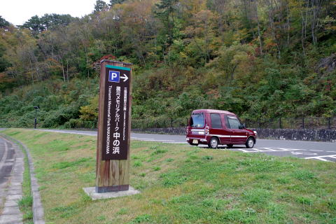
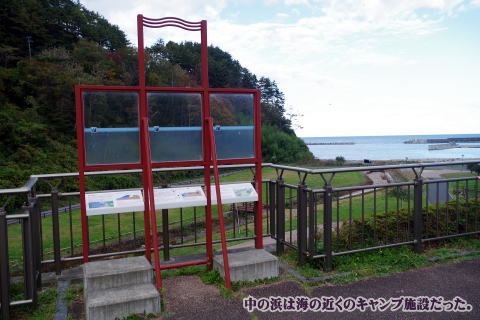
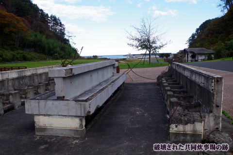
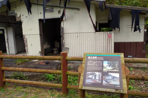
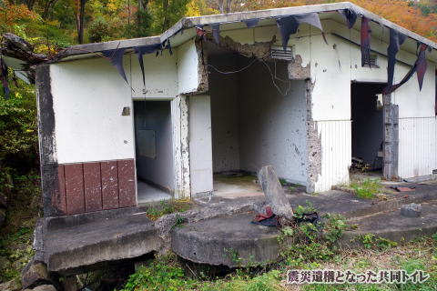
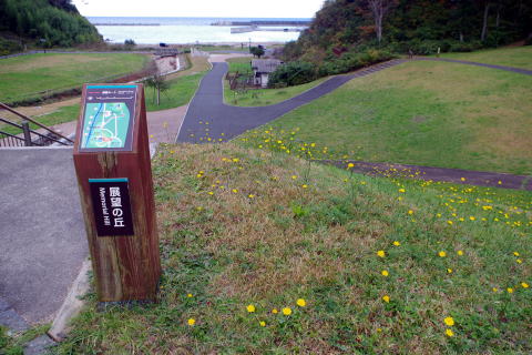
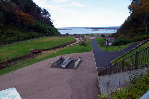
「震災メモリアルパーク中の浜」
かつて、中の浜は海岸部に隣接する緑豊かなキャンプ場だったが、東日本大震災の際、中の浜には15メートルを超える津波が押し寄せ、甚大な被害を受けた。
現在は、キャンプ場のトイレと炊事場を震災遺構として保存し、被災した施設を被災した時のままに見せる「震災メモリアルパーク中の浜」としている。
"Earthquake Memorial Park Nakanohama"
In the past, Nakanohama was a green campsite adjacent to the coast, but during the Great East Japan Earthquake, a tsunami exceeding 15 meters surged into Nakanohama, causing extensive damage.
Currently, the restrooms and kitchen of the campsite are preserved as remains of the earthquake disaster, and the damaged facilities are shown as they were at the time of the disaster, making it the "Earthquake Memorial Park Nakanohama".
https://www.city.miyako.iwate.jp/kanko/nakanohama.html
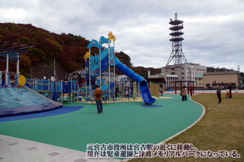
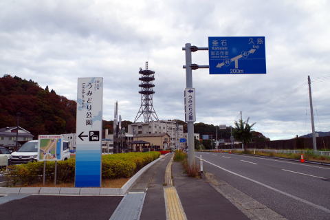
<うみどり公園の震災津波モニュメント>
うみどり公園は、元宮古市役所があった場所に造られた。今は公園となり子ども達のの元気な声が聞こえる。その隣に伝承の塔が建設された
東日本大震災に関する情報をあしらえたモニュメントで、それぞれ記憶・鎮魂・伝承・希望の意味を持つ4つの塔からは、震災の記憶や教訓を学ぶことができる。
メモリアルモニュメントの4つの塔には、記憶・鎮魂・伝承・希望の意味が込められています。
<Earthquake Tsunami Monument in Umidori Park>
Umidori Park was built on the site of the former Miyako City Hall. Now it becomes a park and you can hear the cheerful voices of children. A tower of tradition was built next to it
It is a monument with information about the Great East Japan Earthquake,
and you can learn the memories and lessons of the earthquake from the four
towers, which each have the meaning of memory, requiem, tradition, and
hope.
The four towers of the memorial monument have the meaning of memory, requiem, tradition, and hope.
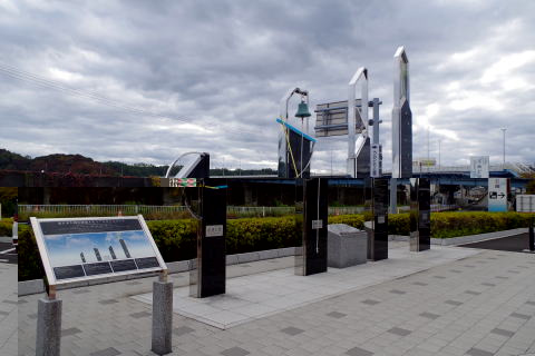
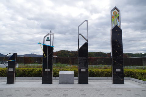
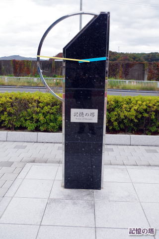

記憶の塔
塔の高さ2011㎜(約2m)
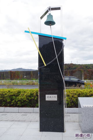
鎮魂の塔
震災時のこの場所の津波浸水高を表しています。犠牲者の方々への追悼の意を込めて、「鎮魂の鐘」を設置しています。
伝承の塔
中央部分に震災の概要を記し、宮古市に関わる震災の情報や被害状況を知ることができます。
(宮古市の震災伝承について詳しくはこちら)
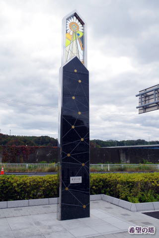
希望の塔
震災から復興までの10年間の歩みを10個の点で表現し、交わる線はこれまでの多くの支援や人々とのつながりを意味しています。上部のステンドガラスは宮古市の花「はまぎく」が表現されています。花ことばは「友好」「逆境に立ち向かう」まさに宮古市を象徴する花です。
tower of memory
It represents 2011 when the Great East Japan Earthquake occurred.
The hands of the clock show 14:46 when the earthquake occurred.
Requiem Towe Tower height 3.4m
It shows the tsunami inundation height of this place at the time of the earthquake. The "Requiem Bell" has been set up in memory of the victims.
Tower of Tradition
A summary of the earthquake disaster is written in the central part, and information on the earthquake disaster and the damage situation related to Miyako City can be known.
tower of hope
The 10-year history from the earthquake to reconstruction is expressed
with 10 dots, and the lines that intersect represent the many supports
and connections with people so far. The stained glass on the upper part
expresses Miyako City's flower "Hamagiku". The language of flowers
is "friendship" and "confronting adversity"
https://www.city.miyako.iwate.jp/toshi/umidorikouen_sisetugaido.html
※岩手県topに戻る。
※東日本大震災topに戻る。